Long Distance Trails – Lehigh & Hudson River


NEW YORK/PHILADELPHIA METROPOLITAN AREA
OPEN SPACE RESOURCE LIBRARY
Lehigh and Hudson River
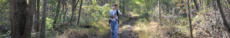
This former railroad that operated from 1886 to 1962 is not a complete trail by any means, but it would without a doubt be fantastic. Many sections are in public ownership, and are described in other sections of this site. ATVs keep many sections open, but they remain in private hands, and should not be hiked without landowner permission.
The Lehigh and Hudson River was originally chartered as the Pequest and Wallkill Railroad, which appears on the 1874 Beers Atlas of Warren County. The proposed line in that charter ultimately saw life as three different rail lines: L&HR, the New York Susquehanna, and Western, and the Lehigh and New England.
The LHR line was constructed in 1886 and operated between Belvidere NJ and Maybrook NY where they connected with other lines. To the south, the LHR had trackage rights over the Belvidere and Delaware Railroad south to Phillipsburg, where it had it's own bridge over the Delaware to access it's yards in the Lehigh Valley (the bridge still stands, visible from Union Square, Phillipsburg. It is still actively used.). To the north, it made it's way to the Poughkeepsie Bridge over the Hudson. The bridge was burned by arsonists, which helped seal the fate of the line (the Poughkeepsie Bridge is now a state park in NY; one of the world's largest pedestrian bridges). The section from Belvidere to Sparta was abandoned in 1986. The section from there north is still operated by New York, Susquehanna, and Western.
While much of the rail bed is in public ownership, much of it is not. This guide is intended to illustrate what the trail COULD BE. In no way does it condone trespassing, and sections open to public are described as such.
Blazing: none
0.00 In Belvidere, there were two junctions for the LHR line to connect with both the northbound and southbound Belvidere and Delaware, or "Bel Del". Because the section north of Belvidere was damaged heavily in the Flood of 1955, it was abandoned and never repaired. Therefore, the northbound connection was abandoned first. Much of this is obscure, and even runs through private yards.The south junction still has tracks in place, and is described here. From the junction site, the railroad breaks away from the Bel Del and passes behind back yards. An ATV path follows it closely.
0.25 The former northbound track to the Bel Del right of way is visible to the north. It is overgrown. Soon, the rail line passes under Rt 620.
0.50 The tracks pass close to Mansfield Street on the left. An old coal trestle is off to the left in this area. Two old railroad cars are still sitting on the last section of track. There was once a station just ahead. Soon, the tracks end and the right of way enters the woods.
0.90 The rail bed crosses the Pophandusing Brook on an old bridge with only railroad ties remaining. It then heads slightly up hill, as it has been filled in a bit approaching a development.
1.05 A gate marks the entrance to an age restricted community built over the railroad bed in 2001. A pathway continues through the development, on or close to the former rail bed.
1.20 The trail reaches Victoria Drive and crosses. It turns away from the former rail bed to the left slightly, as the rail bed has homes built over it. These paths exist in case the entire rail bed becomes developed as a trail.
1.28 Cross Kensington Circle.
1.33 Cross Stafford Lane.
1.40 Reach Weybourne Lane. Turn slightly left and then right onto the next section of path.
1.45 Reach the other end of Kensington Circle. Jog left and then right onto the path.
1.50 The pathway regains the railroad bed, with shrubs planted on both sides.
1.63 Reach Rt 623. The rail bed crosses onto private land ahead. The mileage will continue on the rail bed, but hikers must continue to the left on Rt 623, then right on Pequest Drive. The road route passes by scenic farm land and near to the Pequest River, and reaches Rt 519 in Bridgeville in 2.48 miles. This route is only 0.7 mile longer than hiking the rail bed.
1.90 The rail bed reaches an open field. There are no trees lining the sides, which is very uncommon for old rail lines. Only a line of black cinder dirt marks the former rail route across scenic fields.
2.57 A quarry area parallels the south side of the rail bed.
3.08 The farm road which has followed the rail bed for some time turns away to the southeast. The right of way ahead has been farmed out of existence, and is often planted with corn.
3.33 Reach Rt. 519 in Bridgeville. The old railroad bridge over the highway still stands, but the fill on the east side of the road has been completely plowed away. Now, a junk yard occupies the site. It is necessary to take a detour around. It is unlikely that this section will ever be a trail. A drive to the right on 519 may provide future access.
3.45 Corner of Rt 519 and Pequest Drive. The road walk to bypass the private property is only 0.7 miles longer than walking the rail bed.
3.50 Cross a beautiful arched stone bridge over the Pequest River in Bridgeville. The bridge was recently refurbished by Warren County. Soon, turn right onto Titman Ave. Continuing straight leads to a deli and convenience store.
3.75 To the right is abandoned Edison Road, once the back way to Thomas Edison's Oxford quarry. The bridge over the Pequest was sadly torn out in 2010. It provided access to the LHR rail bed on state park land ahead. Wading across the river and following the old road would lead to the rail bed in 0.1 mile.
3.85 From the former site of the Edison Road bridge, torn out shortly before the Pequest River bride, the rail bed continues east. There are many ATV trails through lovely ivy to the right, followed by the ruins of an old farmstead. A giant Sycamore tree, nearly dead stands at the site of an old agricultural underpass.
4.30 Reach an undecked girder trestle over the Pequest River. Hot Dog Johnny's is visible downstream to the left. To the right, an Eel Rack site, stones leading to a "V" shape are in the water. The bridge is in poor condition. Unnecessary risks should not be taken.
4.40 Farms border the rail bed. There are horses in fences to the right, and heavily posted property to the left. Do not trespass.
4.60 Reach Mill Street in Buttsville. Yards have overtaken the rail bed ahead, though it is public land.
4.70 Reach Mill Street again. Former grade crossing and old iron truss road bridge to the right. The rail bed ahead is clear, but it is still privately owned. Hikers may turn left on the former road to Rt 46 and continue to the intersection of Rt 31 and 46, where the former Lackawanna Railroad once crossed. From here it is possible to descend to the rail bed. For the purposes of this guide, mileage still continues along the rail bed.
4.95 The rail bed passes beneath Rt 31. Note how the right of way is a bit wider here. This is probably because this was the junction with the nearly forgotten Lehigh and Oxford Railroad. The Lehigh and Oxford broke away from the LHR and made it's way north, across Buttsville Road, then across East Quarry Road out to Thomas Edison's Oxford Quarry. Very little remains of this line, save for some small fills, bridge abutments at Buttsville Road, and small tributary bridge abutments further north. The line became obsolete with the construction of Edison's Pohatcong Railroad which broke off of the Lackawanna main line.
Continue on the rail bed ahead, entering Pequest Wildlife Management Area. It is a public trail from here to mile 9.20 ahead. The right of way is nice, but the surface has very uncomfortable ballast rock.
5.03 Cross the Pequest River directly below the Lackawanna Railroad's Pequest Viaduct. This three arch concrete span is dwarfed in size by the four great viaducts further north, but is still an interesting sight to see. This bridge replaced the original stone arches constructed in 1856. The LHR crosses the Pequest on a through style girder bridge. It is undecked and extreme caution should be taken if it is crossed.
Loop hikes are possible from this point to Pequest Furnace site using the Lackawanna Railroad. Ahead, an old road now used often by ATVs leads up hill to the Lackawanna right of way.
6.08 What appear to be tailings on the slope to the right appear, as the Pequest River comes close again to the rail bed. A rugged path follows the tailings to the former junction of the Warren Railroad (Lackawanna) and Pequest Furnace Railroad.
6.20 The LHR crosses the Pequest River on a nicely decked through style truss bridge. Just before, a path leads down hill, then back up again parallel with the river. Shortly, the path splits. The left fork leads deeper into Pequest WMA to the tailings site, while the path to the right ascends to the right of way of the Pequest Furnace Railroad and many foundations from the Pequest Furnace operation. Following the right of way ahead leads to the Warren Railroad (Lackawanna) at the entrance to the dramatic Pequest Cut.
Continue across the bridge and across Pequest Furnace Road, passing the furnace site on the right.
6.40 The rail bed skirts back yards to the right, and parallels Rt 46 to the left.
6.70 A path joins from the right. It leads back to a bend in Pequest Furnace Road. It was perhaps part of the Pequest Furance railroad system. The river comes close to the rail bed here.
7.65 Reach a parking area on the right, and soon cross the access road to Pequest Trout Hatchery. A short fisherman's path leads from the parking area, and a short walk up the road leads across the river where more trail connections are possible. Continue across the road.
7.90 Cross the Pequest again on another nicely decked girder bridge. A very long stretch of unbroken woods is ahead.
8.75 Cross a private driveway. Have a look at the humorous signs facing the rail bed on the driveway from the south.
8.85 Old farm site on the right of the trail.
9.00 The Pequest River appears close to the left of the trail. There is a rope swing into the river nearby.
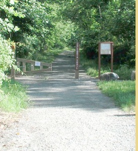
9.20 Reach Pequest Road. Parking available. This is the end of this section of trail. The rail bed ahead lies on private land, although it would make an excellent trail. It is not as clear as previous sections, and ties are still in place much of the way. For the purposes of this guide, the mileage will continue describing the rail bed, in hopes that it may one day be open to public.
10.10 The rail bed crosses a high girder trestle with ties remaining over the Pequest River and a driveway.
10.30 A Telltale existed in this area until recently. A telltale is a pole with lines hanging from it which would warn engineers of overhead obstacles. It is unclear why one of these might have been needed in this area.
10.55 Rail bed crosses a farm road known as Hudson Lane.
10.97 The rail bed crosses Old Cemetery Road. Just before reaching the road, it is badly overgrown. It would be necessary to walk through an adjacent field. To the left of the right of way is an historic church and cemetery along Rt 46. There is also a convenience store nearby. Ahead, the rail bed passes through a shallow cut, and is then sandwiched between Rt 46 and Cemetery Road. Rails are still in place through the village of Great Meadows to just beyond the old station.
11.35 Reach the cleared station area, now an engineering company. The Great Meadows Station is the most unique looking station on the line. When the LHR was constructed through this area, the towns of Danville and Townsbury fought for which of the two would recieve a railroad station. LHR was willing to build only one. The conflict was such that LHR decided to build the station between the two settlements and name it "Great Meadows". In the long run, Danville won the battle when the town name was changed to Great Meadows to incorporate the station. The rail bed continues under Rt 46.
11.48 The rail bed crosses a small bridge over a water filled ditch. Ahead, the rail bed crosses a private area with junk cars, and borders the end of Island Dragway on the left.
11.60 The rail bed reaches the north end of the clearing near Island Dragway.
11.65 The rail bed crosses the Pequest River on a concrete bridge.
11.70 The rail bed resumes on public land under ownership of Warren County. It skirts back yards to the right and fields to the left. The public greenway continues from here.
12.60 Cross a private farm lane. Continue on the rail bed through lovely pastoral settings.
13.05 The rail bed exits the fields and enters a heavily wooded area.
13.25 Pass a cleared area along the right of the trail.
13.65 Enter the Alphano Flats. There is a huge clearing, part of the Alphano sod farms. There is very little shade for the next
13.73 The rail bed crosses an old wooden tie bridge over a wet ditch, with nice views out across the sod farm. Proceed with caution.
13.93 Cross the access road to the abandoned industrial site on the left of the trail. The rail bed can become somewhat overgrown ahead.
14.15 Skirt woods on the left of the trail.
14.45 Cross Young's Island Road and enter a wide sod farm area.
14.80 Exit the sod farm area.
14.85 Pass by ball fields on the right of the trail.
15.03 Cross Freeborn Lane followed by new housing development on the right.
15.22 Housing development ends, continue through old farm land, which looks not to be in use.
15.88 Cross a farm lane before reaching Rt 80.
15.95 Pass beneath the eastbound lane of Rt 80, followed by the westbound. The bridge has slanted edges, comfortable for sitting.
16.00 The rail bed becomes very overgrown on the north side of Rt 80. A path, which can also be overgrown, parallels closely to the right.
16.20 Long Bridge. Cross a concrete bridge over the Pequest River and reach a small parking area on Long Bridge Road. Cross the road cautiously.
16.40 Cross a concrete bridge over the Pequest River. Note the size difference of the river compared with areas further south.
16.60 Fields skirt both sides of the rail bed.
17.48 Cross Rt 612 in Allamuchy. The Allamuchy Freight Station is on the right, and has been beautifully restored to it's former glory. For many years it was used to store hay. Continue on the rail bed as it enters the woods.
18.27 Reach Tranquility Farm Lane, a private drive. This is the end of this public section of the rail bed. Again, the mileage will continue in hopes that it will one day be open to public. The section ahead is badly overgrown, sometimes wet, and even has pipes laying across it to keep ATVs from riding through. It is surrounded by fields.
18.75 Leave Warren County, enter Sussex County.
18.85 The rail bed skirts the Tranquility Cemetery on it's north side.
19.00 End of the cemetery.
19.08 The rail bed crosses Kennedy Road. The Tranquility Post Office is ahead. The railroad went to the right of the parking lot. This next section can be hiked.
19.20 The access road behind the post office leads to the edge of a Green Township park, known as Evergreen Park.
19.35 This section of the rail bed has been cleared as a trail. The trail breaks away to the left of the rail bed. After a bit, the rail bed becomes badly overgrown.
20.20 The rail bed comes to and parallels closely Rt 603.
20.40 The rail bed crosses Creek Road.
20.77 The rail bed crosses the access road to Trinca Airport.
20.95 The rail bed crosses a farm lane.
21.10 The rail bed crosses Rt 603. It is again public land on the other side. Continue into the woods on the right of way, which becomes clear enough to walk shortly.
21.25 Cross an old farm underpass. Notice the size of the abutments in comparison with the railroad bed. Perhaps it was anticipated that widening the line would one day be necessary. There are good views across the field to the south where an old style windmill stands.
21.55 Reach Whitehall Road. At this point, the former LHR underpass beneath the Lackawanna Cutoff is visible ahead. The fill seen here is known as the Pequest Fill, and it is the largest railroad fill in the world. The rail bed crosses private land for a short distance, and although it is state land, the culvert underpass has been blocked off for boat storage. To get past this, hikers will have to turn left on Whitehall Road, right under the Lackawanna Cutoff on Rt 603 (narrow culvert, use extreme caution), and continue to Brighton Road for a right turn where the rail bed is reached again. The mileage here is presented as if there were no obstacles.
21.80 Lackawanna Cutoff underpass. It is blocked off by fences, which may be illegal. The rail bed ahead is public land, but it is difficult to reach from the south due to the gated culvert. The only other way would be to climb over the fill of the Lackawanna Cutoff where pedestrians are not allowed.
22.07 There are abutments for a former farm overpass in this area. The rail bed becomes badly overgrown ahead.
22.23 Reach Brighton Road. The rail bed is on public land ahead, but is badly overgrown. It continues through beautiful farm land to the north.
22.94 Agricultural crossing of the rail bed.
23.15 The rail bed exits the fields and enters woods. It remains badly overgrown.
23.50 Reach the Sussex Branch Trail (See Sussex Branch Trail). This was Andover Junction. To the left, Sussex Branch Trail (also the route of Liberty-Water Gap Trail) leads to Branchville, and to the right it leads to International Trade Center in Mt. Olive.
23.58 After crossing a parking lot, the rail bed reaches Rt 206. Although quite overgrown, it is public land ahead.
24.00 The rail bed is mowed in this area as part of someone's back yard. Ahead, skirt the right side of Gardeners Pond.
24.40 Closely parallel Limecrest Road.
24.58 Reach a parking area, boat and fishing access to Kittatinny Valley State Park. The historic Slater House sits on the shore of Lake Aeroflex (New Wawayanda Lake, and originally Andover Pond), the deepest natural lake in NJ, and part of the headwaters of the Paulins Kill. The Slater House is now a park police headquarters. The Andover Aeroflex Airport is also here. Ahead, the rail bed runs beside the lake rather closely.
25.40 The rail bed crosses a lawn and private driveway, closely parallel with Rt 206.
25.55 The rail bed crosses a utility right of way.
26.20 The rail bed reaches Lake Iliff Road. This is the end of the public land on the LHR rail bed. The remaining mileage is presented solely to illustrate the potential connectivity with the Paulins Kill Valley Trail to the north. This guide is not intended condone trespassing.
The rail bed continues along the west side of Lake Iliff.
27.00 After paralleling a golf course on the right, the rail bed passes beneath Newton-Sparta Road.
27.56 The rail bed reaches Mulford Road. It continues ahead parallel to an apartment complex on the left, with Lifecare Drive on the right.
28.10 Pass the last building of the apartment complex and continue, soon skirting the south side of another golf course.
28.26 A dirt road joins the rail bed.
28.50 Cleared railroad tracks resume. This section is used as an industrial spur, often to back cars up.
29.20 The tracks cross Limecrest-Randazzo Road.
29.35 The tracks cross a creek.
29.70 Sparta Junction. The New York, Susquehanna, and Western Railroad crossed and connected with the LHR line here. Ahead, the NYS&W operates the former LHR into NY state, to the right, the NYS&W main line continues east to Jersey City as it always has. To the left, the abandoned NYS&W is now Paulins Kill Valley Trail, which extends just shy of thirty miles west to Columbia NJ.

Hosting courtesy of Firebrand Communications. Website design by SGF Studios
©2012 Metrotrails unless otherwise noted • All rights reserved