Skylands - Hunterdon County, NJ


NEW YORK/PHILADELPHIA METROPOLITAN AREA
OPEN SPACE RESOURCE LIBRARY
HUNTERDON COUNTY
Alexauken Creek Wildlife Management Area
Managed by NJ Fish, Game and Wildlife
Acreage: 689.54
Map: http://www.nj.gov/dep/fgw/pdf/wmamaps/alexauken_creek.pdf
Parking:
Rocktown-Lambertville Road: Unlocated
Trails:
There are no formal trails in these properties, and the state WMA map does not present the ones along the creek closer to Lambertville, which are between the old rail line and roads. Old farm roads cross the main preserve section and are adjacent to South County Park of the Hunterdon County Parks Department.
_____________________________________________________________________________________________
Beaver Brook Ravine
This undeveloped open space has lovely woods roads, but no developed trails. It is also home to the historic ruins of Amesbury Furnace. Taylor Steeworkers Historic Greenway may be extended here.
_____________________________________________________________________________________________
Clinton Wildlife Management Area
Managed by State Fish, Game, and Wildlife
Acreage: 1,993.15
Map (east): http://www.state.nj.us/dep/fgw/pdf/wmamaps/clinton_east.pdf
Map (west): http://www.state.nj.us/dep/fgw/pdf/wmamaps/clinton_west.pdf
Parking: See map links
Van Syckles Road: Lat: 40°39'24.62"N Long: 74°57'18.49"W
Van Syckles Road 2: Lat: 40°39'20.28"N Long: 74°57'46.71"W
These parking areas offer access to the Highlands Trail.
Trails:
Highlands Trail (Teal diamond blazed): A section of the Highlands Trail passes through Clinton WMA, but otherwise there are no real developed trails. Many fields and old woods roads exist on these properties, and are very interesting to walk.
The Highlands Trail enters across from Spruce Run Recreation Area and parallels Van Syckles Road. It crosses the road once more, and passes through some lovely fields, along woods roads, and over a small but beautiful inlet before descending back to Van Syckles Road across from an historic iron master's house.
A former section of the Highlands Trail continues through Clinton WMA, and was proposed as another access spur. Where the HT turns left in the fields from Van Syckles Road, follow the edge of the field to the right, to the tree line. Turn left and skirt the tree line all the way nearly to a brook. Just before, a woods road heads up hill. The HT route once followed this. Blazes may still be visible where it turned from the road and descended to the brook. At the end of trail blazes, a short walk to the left leads to a beautiful little confluence of two brooks. The HT route was originally planned to head north and follow the abandoned alignment of Polktown Road, which is now a dead end. (For more information on the Highlands Trail: See Long Distance Trails)
_____________________________________________________________________________________________
Columbia Trail
Managed by: Hunterdon County
A seven mile section of this 15 mile trail is within Hunterdon County, and connects with Teetertown Connector Trail, The Highlands Trail, Liberty-Water Gap Trail, and Taylor Steelworkers Historic Greenway. (See Columbia Trail in Long Distance Trails)
Map: http://www.traillink.com/trail-photos/taylor-steelworkers-historical-greenway-.aspx
_____________________________________________________________________________________________
Delaware and Raritan Canal State Park
Managed by NJ Dept. of Parks and Forestry
Delaware and Raritan Canal: See long distance trails
Bel Del Rail Trail: See long distance trails
Bulls Island Foot Bridge and camp grounds offer pleasant walks, and the foot bridge makes possible connecting hikes with the Delaware Canal in PA.
Delaware River Bluffs State Park
Managed by NJ Parks and Forests
Acreage: ?
White Oak Trail map: http://www.dandrcanal.com/pdf/DelawareTownship_TrailSign_4-10.pdf
Parking
Bulls Island, Rt 29: Lat 40°24'39.59"N Long 75° 2'4.14"W
Trails
White Oak Trail: Non standard, metal arrow markers. (Ironically, Metrotrails scouted and proposed a trail on a similar route in 2006, but did not have the resources to make it happen). This trail begins at Bulls Island area along Rt 29. Across the street, just south of Quarry Road, the trail heads into woods and soon reaches a hillside where stands an enourmous White Oak for which the trail takes it's name. It ascends to the right of a large abandoned quarry to the right. Do not approach the quarry, the walls are very brittle and extremely dangerous.
The trail makes it's up hill and across Quarry Road at an angle. Quarry Road is a dirt road and is very scenic to walk itself. It might make a good return trip. Along the road, there is the ruins of a flume bypass which carried water away from the quarry in the days of it's operation.
The trail crosses and climbs through state park land, and crosses nicely built wooden bridges over small tributaries. The trail is wide and easy to follow, so the lack of double blazes at turns isn't as big a deal.
Near it's end, the trail crosses what was probably an earlier alignment of Federal Twist Road. It then reaches the current Federal Twist Road where it ends. Raven Rock Road is across the street. 0.3 miles ahead is the entrance to Mimi's Trail in the Zega section of the Lockatong Creek Preserve. The preserve can be entered through fields to the left even earlier than the trail head, and followed to that point.
_____________________________________________________________________________________________
Flemington Outlets
Parking:
Lat 40°30'8.73"N Long 74°51'42.95"W
In the past, NYNJTC's New Jersey Walk Book, the best hiker resource guide ever printed in the state, recommended a walk around Flemington's Outlet stores, to make a loop with Morales Nature Center and Uplands Reserve. We at Metrotrails always found it funny that Hunterdon apparently had so few places to hike that they had to recommend hiking the outlet malls. In reality, it had more to do with Hunterdon Parks unwillingness to supply information or to return calls. Regardless, the truth is Flemington is a beautiful and very walkable town. Beginning at the outlet malls along Rt 12 and heading north, it is a lovely walk not only to Uplands but to the cemetery also on Capner Street, Court Street Park, and the historic Flemington Courthouse and Union Hotel made famous by the Lindberg Trial.
_____________________________________________________________________________________________
Hampton Boro Park
Managed by: Hampton Boro
This park, which has no real trails, is substantial enough in size to offer short walking opportunities, and borders a nice section of the Musconetcong River. In addition, it borders another section of Musconetcong Wildlife Management Area, and the abandoned former Rt 31 bridge just to the east.
_____________________________________________________________________________________________
Ken Lockwood Gorge Wildlife Management Area
Managed by NJ Fish, Game, and Wildlife
Acreage:
Parking: Both ends of Raritan River Road, north of High Bridge, south of Califon.
Trails:
Columbia Trail (Unblazed): Columbia Trail is a county park which is surrounded by the state WMA. (For more information on the Columbia Trail: See Long Distance Trails)
Highlands Trail (Teal diamond blazed): A section of the Highlands Trail is the only developed trail within Ken Lockwood Gorge WMA. The trail is co-aligned with Columbia Trail from the northeast, and turns off just after crossing the Ken Lockwood Gorge Trestle. It switches back through woods, offering some seasonal views of the gorge, and then continues on a narrow foot path through woods, coming out at an old driveway. Highlands Trail turns right and follows the driveway out to Rt 513 where it turns left. There is no parking at this end. (For more information on the Highlands Trail: See Long Distance Trails)
Raritan River Road (Unblazed): This lovely dirt road through the gorge was washed out badly in 2003, and several times since. It was decided not to re-open it as a through route for traffic, instead opening parking areas at either end, and installing two handicap accessible fishing docks on the South Branch of the Raritan River. A walk on the closed road is quite beautiful, leading through the deep gorge intimately close with the river strewn with rocks in a way uncharacteristic of New Jersey.
_____________________________________________________________________________________________
Musconetcong Wildlife Management Area
Managed by: NJ Fish, Game, and Wildlife
Acreage:
Map: http://www.nj.gov/dep/fgw/pdf/wmamaps/musconetcong_riv_butlers.pdf
Trails:
A short section of the former Warren Railroad, part of the Delaware, Lackawanna, and Western Railroad's original main line (1856-1955) runs through a portion of the property from Changewater, at the site of the former Changewater Trestle, removed in 1959. The line was double tracked, but only one set of ties remains, and it is an enjoyable walk for those intrepid enough to climb the high hillside near the trestle site. This is an unofficial trail, and the public land does not stretch as far as the next road, Dutch Hill Road, but would make an excellent trail.
_____________________________________________________________________________________________
Nassau Tract
(see Taylor Steelworkers Historic Greenway on this page)
_____________________________________________________________________________________________
Point Mountain Reservation
Managed by Hunterdon County Parks Department
Acreage:
One of the greatest parks in the entire Skylands Region, the Point Mountain Reservation has everything anyone can ask for in a park. Scenic vistas, beautiful riverside, ponds, historic ruins, a waterfall, mixed hardwood forests, fields, and of course many miles of trails.
Most trails in Point Mountain are standard blazed, in addition to using oversized plastic markers which state "Trail" obviously on them. Many Hunterdon markers have arrows on them, but the often do not point in the correct direction. Note: The waterfall is off trail. Maps may also be somewhat inaccurate.
Map: http://www.co.hunterdon.nj.us/depts/parks/ParkAreas/PointMountainCentralSouth/TrailMapALL.pdf
Trails
Map of central section: http://www.co.hunterdon.nj.us/depts/parks/ParkAreas/PointMountainCentralSouth/TrailMapCentral.pdf
Ridge Trail (Orange blazed): From the main parking lot on Point Mountain Road near the Musconetcong River bridge, the orange blazed Ridge Trail begins just inside the woods where the blue blazed River Trail goes left. The Ridge Trail follows a rather gradual approach, keeping near to Point Mountain Road for a bit, then turning to begin the ascent over rocks. It turns again, skirting the ridge before making the more dramatic ascent up stone steps, well constructed by an SCA (Student Conservation Association) Crew. The trail turns abruptly left when a house comes into view ahead, and reaches a small outcropping before making it's final steep ascent to The Point. There is a fantastic view of the Musconetcong Valley, Mansfield Township with it's elementary school, the Port Murray Road intersection with Rt 57, a horse track, and the village of Anderson with it's prominent church steeple. Beyond, the Pohatcong Mountain is in the foreground, followed by West Oxford Mountain and County House Mountain. Beyond, sticking up like a camel hump is Mount No More, and on a clear day the Kittatinny Ridge's flat top can be seen in the distance, including the arc of Mt. Tammany.
The Ridge Trail turns down hill to the right, and the Yellow Trail breaks away to join the white blazed Old Turnpike Road-Mountaintop Trail.
Ridge Trail begins to ascend once again to a higher point. On the left, there is another rocky outcropping with a hole resembling a dinosaur foot print in it, just off trail. Ridge Trail gains a bit more elevation before reaching it's highest point, 934 ft above sea level where a forward jutting rock on the left of the trail offers limited views to the northeast. Ridge Trail descends a bit from here, heads to the left and again to the right, cutting across the ridge to skirt a stone row to the south. The white blazed Old Turnpike-Mountaintop Trail joins in from the right. Ridge Trail continues, regaining the ridge with more seasonal views before descending to a small brook crossing. The trail can be difficult to follow in this area, until it reaches a woods road. To the right, the woods road leads to Camp Bernie of the YMCA. The turn here is easy to miss if coming from the opposite direction. Ridge Trail descends via the old woods road, passing springs on the right which may make for wet footing. The white blazed Old Turnpike-Mountaintop Trail turns right from Ridge Trail, and Ridge Trail descends further to the edge of the Rosan Fields. Keep to the left of the fields, and pass through an opening at the end, reaching another field. To the right, there is a parking area off of Penwell Road 0.3 mile away. The River Trail (blue blazed) turns right.
River Trail (Blue blazed): The can be several different routes, which we attempt to describe here. Starting at the intersection with the Ridge Trail in the Rosan Fields, 0.3 mile from the Penwell parking area, the River Trail skirts the edge of the field to the left. At the end of the field, it turns sharply into the woods and begins to descend to the Musconetcong River. An unmarked side trail to the right follows the river and disappears. River Trail continues on a nice wide path, crossing a stream in a short distance. It then follows the river onto a flood plain and splits in two. To the left, it heads up hill gradually on a woods road to the parking area where the Ridge Trail begins. To the right, it turns to more closely follow the river on a foot path, the most scenic route. This section of the trail passes by lovely large trees, and then crosses a berm that was once the earthen dam to a mill at this site. Rock rubble is all that remains of this historic site along the Musconetcong.
River Trail comes out on Point Mountain Road next to the historic Point Mountain Truss Bridge. From here, hikers may walk the short distance left up the road to the parking lot, or continue across on the River Trail. Ahead, the trail passes through a wide flood plain along the Musconetcong. It can be very wet seasonally. After a bit, the trail begins to meander from the riverside through dense undergrowth. A puncheon constructed by volunteers Michael Helbing and Jillane Becker over a very wet area has recently disappeared due to flooding. After the wet area, the trail ascends to higher ground above the Musconetcong. It follows the river down stream for a short distance, then turns back toward the parking area, parallel with Musconetcong River Road. It skirts the sides of pits, either old charcoal hearths, mine explorations, or former buildings, before reaching Point Mountain Road across from the parking area, at what was once a utility right of way.
Rosan Field Trails: Unblazed. Many trails are maintained as mowed paths at Point Mountain at the Rosan Fields, offering many different shorter loop opportunities with the Ridge and River Trails.
Old Turnpike-Mountaintop Trail: Beginning from a parking lot on Old Turnpike Road, this trail connects the north and south sections of the Point Mountain Reservation. It begins by heading through young successional forest with many invasive species, leading gradually up hill. It parallels the abandoned former route of Hermit's Lane, which once connected Penwell Road with Old Turnpike Road. At an intersection, the trail turns left into more mature woods and begins to follow an old woods road up hill, gradually at first and then steeply. The blue blazed Point Mountain South Trail turns off ot the left on an obscure old logging road. Near the top, Point Mountain South Trail reconnects. After reaching the very top, the red blazed Stone Row Trail joins on the left, and the Old Turnpike-Mountaintop Trail begins to descend to the right on a foot path. The trail remains gradual on it's descent for some time, and then drops steeply near the yellow property boundary signs to Penwell Road.
The trail jogs to the left on Penwell Road briefly, and then re-enters the woods, soon to reach a lovely creek. It follows the creek down stream and then crosses on rocks, which can be difficult in times of high water. Another small parking area is available on Penwell Road to the right of the trail here, at an old house site.
Continue up hill a bit, then skirt the hillside with fields below on the right. The trail continues on to the Ridge Trail (orange blazed). From here, the white blazes currently end, but the trail runs concurrently with the Ridge Trail to the left, up hill on a woods road. The trails turn away from the road indistinctly and cross a wet area, then ascend to the ridge. At a point where the Ridge Trail briefly descends from the ridge to parallel a stone row on the left, the white blazes resume and Old Turnpike-Mountaintop Trail turns left, passing through another wet area. It then continues on a wide path with stones placed in the middle to use during wet weather. After passing an old barn foundation, the trail turns sharply to the left (a woods road continues straight to Point Mountain Road) on small steps. The trail continues through dense young forest to a wider trail, which leads to Camp Bernie of the YMCA to the left. Turn right on the wide path and cross Point Mountain Road diagonally to the left. The trail continues through easy terrain to reach the Vista Trail (yellow), and turns hard to the left.
From here, Old Turnpike-Mountaintop Trail continues through thick woods, and crosses a small stream. It then follows on and close to an old woods road, which passes near a beautiful old spring house ruin, best seen in the winter, to the left of the trail. A keen eye may spot old pickup trucks from the 1940s off in the weeds (additionally, a left turn on the woods road away from the marked trail leads to an old tractor with metal wheels). The trail emerges from the woods into an overgrown field, then cuts through a line of trees to another field. It follows the right side of the field, then cuts to the left to pass two wetland restoration project ponds. It continues straight across the field to end at a parking area on Mountaintop Road. Much of the field section of this trail is unmarked, though there are occasional marker posts.
Vista Trail (Yellow blazed): This trail makes an easier connection to the viewpoint atop Point Mountain. It crosses Point Mountain Road at a pull off parking site, where it leads up hill via switch backs to the Ridge Trail near the view point, and to the west across a wetland and up to the white blazed Old Turnpike-Mountaintop Trail.
Stone Row Trail (Red blazed): This short trail connects the blue blazed Point Mountain South Trail with white blazed Old Turnpike-Mountaintop Trail. The most prominent feature of this trail is an extraordinary stone row, vertically constructed on the south side.
Point Mountain South Trail (Blue blazed): This trail breaks away from the white blazed Old Turnpike-Mountaintop Trail on it's ascent up from Old Turnpike Road, and follows an obscure old woods road, probably used for logging. It offers seasonal views to the north. The woods road disappears, and the trail continues as a foot path, cutting hard to the right and ascending. It eventually joins another woods and returns to the Old Turnpike-Mountaintop Trail
_____________________________________________________________________________________________
Springside Farm
(see Taylor Steelworkers Historic Greenway on this page)
_____________________________________________________________________________________________
Spruce Run Recreation Area
Managed by NJ Parks and Forests
Acreage: 2012
Parking: Included are only three parking areas coordinates, because there are far too many redundant ones to post all of them.
Van Syckles 24 Hour Lot: Lat: 40°40'24.99"N Long: 74°55'3.54"W
Highlands Trail entrance, Van Syckles (sometimes closed, Summer weekends):
Lat: 40°40'9.94"N Long: 74°55'26.07"W
Spruce Run entrance: Lat: 40°39'36.35"N Long: 74°56'17.73"W
Trails:
Highlands Trail: A section of the Highlands Trail passes through Spruce Run. From Van Syckles Road, after descending via Serpentine Drive, the trail turns left onto Van Syckles Road east, then abruptly right into the parking lot, which is fenced in during Summer weekends. The trail makes it's way through a lovely evergreen grove, then through very dense thickets of Autumn Olive thicker than any trail we at Metrotrails have seen. The trail crosses Boat Launch Road, then continues through more invasive undergrowth before reaching a lovely wildlife observation blind. It then continues out to Boat Launch Road once more and follows it to the main entrance road. Highlands Trail exits the park at the main entrance, and turns left on Van Syckles Road before turning right into Clinton Wildlife Management Area. (For more information on the Highlands Trail: See Long Distance Trails)
Beach Path: This nice path isn't really a hiking trail like others, but it's a lovely walk from the tower area of Spruce Run west to the beach complex. It passes by picnic area #1 and an historic dog training area that predates the reservoir and recreation area.
_____________________________________________________________________________________________
Taylor Steelworkers Historic Greenway
Managed by: Union Forge Heritage Association
Trails:
7.5 miles, blazed yellow, with red and blue spur trails.
This trail passes through various properties linking historic sites that were once part of the Taylor Iron and Steel Company, later Taylor-Wharton, the second oldest company in American history.
Completed in 2010, the trail begins on the Columbia Trail a short distance from Rt 513 in High Bridge where there is parking. From a large brown sign, it heads down hill to the former TISCO site. A red blazed spur trail leads shortly to a dead end overlooking the Lake Solitude Dam, the last remaining example of an I-beam dam in New Jersey.
The trail passes by the TISCO building, the oldest office building in America, currently scheduled to be restored. It then crosses a circa 1890 carnegie truss bridge, then follows an easement across Custom Alloy property along a chain link fence. The trail turns left through young forest, and passes the Kyle Zalinsky memorial. Kyle was one a dedicated hiker, and one of the volunteers who helped to make the trail possible. Soon, the trail reaches the masonry ruins of the former Bloomery Forge to the left. The main trail turns right on an old road, while a blue blazed side trail leads right, ahead to the Solitude House, where John Penn was held prisoner of war during the American Revolution. The trail continues past a community garden and out to another viewing point of the Solitude Dam where it ends.
The main trail continues out to River Road across from the intersection with Nassau Road. It continues up Nassau Road and then turns left into the Nassau Tract. It continues through lovely mixed hardwood forest, across a stream, and then back to another portion of Nassau Road. It follows the little used road to the left, and soon turns right into Springside Farm, also High Bridge Boro open space. It follows the farm roads, passes historic farm buildings, and becomes obscure. Past the barns, it turns sharp left up into the Springside Woodlands. Here, a loop marked with arrows leads in a circuit. It is planned to extend the TSWHG Trail to Herman Thau Road.
_____________________________________________________________________________________________
Teetertown Nature Preserve
Managed by Hunterdon County Parks Department
Acreage: 302
Map: http://www.co.hunterdon.nj.us/depts/parks/ParkAreas/Teetertown/MountainFarmTrailMap.pdf
Map with mileage: http://www.co.hunterdon.nj.us/depts/parks/ParkAreas/Teetertown/trailmap.pdf
Geology Trail Map: http://www.co.hunterdon.nj.us/depts/parks/guides/geology/Teetertown.pdf
Trail Description: http://www.co.hunterdon.nj.us/depts/parks/ParkAreas/Teetertown/info.htm
Trails: Not all trails are standard blazed. Hunterdon insists on using plastic markers with arrows. You may find arrows pointing left or right where a trail goes straight.
Old Orchard Trail (Unblazed, 0.6 mile): From the parking area near the Mountain Farm barns, the trail follows the paved roadway to the south. Two old fruit trees remain along the road. Soon, the trail is a mowed path along the edge of a former Peach orchard. NJ was the nation's top producer of peaches until the blight of 1890. The trail descends, then follows the lower end of the field before ascending on the other side to return to the roadway/Pond Trail to the parking area. At the bottom of the hill, a side trail connects with Blue Trail.
Pond Trail (Unblazed, 0.5 mile): This trail is actually an access road. It begins at the parking area and crosses an open field area, and connects with the Orchard Trail. Pond Trail enters a wooded area, pases a picnic area on the left, and then crosses the dam of Mountain Farm Pond. It then ascends with other mowed paths breaking off to the right, and another access road to the left which leads to additional parking off of Pleasant Grove Road. The Pond Trail continues out along an open activity field perimeter, passes camp sites on the left, and then ends at the group camping sites. At the end of the fields, accesses to the red and white trails are across to the south of the activity fields.
Red Trail (Red plastic markers, 1 mile): Red Trail leads from the activity fields and passes wilderness camping areas. It also passes by an excellent handicapped accessible camp site constructed by Eagle Scout Andy Trontis. Red Trail descends slightly to join with White Trail. A portion is co-aligned with White Trail on old woods roads.
White Trail (White plastic markers) Both ends of White Trail are on Hollow Brook Road, in Teetertown Ravine. The trail ascends at it's northern terminus along an old woods road, then makes a turn to the south and joins the Red Trail. Together, both trails descend once again to Hollow Brook Road. Hollow Brook Road is a splendid dirt road along a beautiful creek, and can be used to make a good loop hike.
Blue Trail (Blue blazed with additional plastic arrow markers, 0.6 mile): One of the nicest trails in the preserve, it is one of the few open only to foot traffic. Blue Trail descends from Red and White Trails across a small spring, then through thick undergrowth. Along it's route, it passes along and across an old woods road, and follows a small ridge with seasonal views of the countryside before descending steeply along an old stone wall to Teetertown Road where it ends at an old farm site.
Although Blue Trail ends, it can be used to make the best loop hike available here. Turn left along the road. You will come to a small bridge over the brook, where a small waterfall is visible in the back yard. The nice old house on the corner was once the home of television personality Merv Griffin. In fact, the reason his programs read "Califon Enterprises" was because he technically had a Califon address. Turn left at the intersection onto Hollow Brook Road and continue. Pass Ravine Road on the right, and soon Hollow Brook Road changes from paved to dirt, and crosses a beautiful stone arch bridge. Hunterdon County is home to more of these little bridges than anywhere else in North America, with over 200 examples. The road turns right into Teetertown Ravine, with old quarry walls across the creek to the right. These were part of the former Middle Valley Trap Rock Company. A railroad line known as the Middle Valley Railroad broke off of the High Bridge Branch of the Central Railroad of NJ (Columbia Trail) in Middle Valley to access the quarry. Plans were being made to convert this spur line to a connector trail, but have not moved along. Soon, reach the Geology Trail, about a half mile from where the Blue Trail ended.
Geology Trail (Unblazed except self guided markers, 0.16 mile): This self guided nature trail connects the White Trail with Hollow Brook Road. Though it is short, Geology Trail offers a more rugged climb than other trails, and is quite lovely. It passes by very nice rock outcroppings.
Teetertown-Columbia Connector Trail (Marked with brown park signs with arrows; non standard, 2 miles): This trail is mostly a road walk, following lovely back roads mostly. It was intended to follow the former Middle Valley Railroad directly to the Columbia Trail, but that plan never came to fruition. From Valley Brook Road on the Columbia Trail, head west, then make an immediate right onto Vernoy Road. Follow the road out to Rt 513 about a half mile from Columbia Trail. Cross 513 onto Trimmer Road. Look off to the right, and the original bridge site over the South Branch of the Raritan can be seen to the left of it's successor.
Trimmer Road takes a ninety degree bend 0.8 miles from Columbia Trail, and continues through farm land to Maple Lane at 1.2 miles. Turn right on Maple Lane and continue to Hollow Brook Road, and turn right. The trail follows this road past a fenced in area with very curious goats. At 1.6 miles, Teetertown Road intersects on the left. The house on the corner of these two roads was formerly the home of television personality Merv Griffin. "Califon Enterprises", appearing at the end of Griffin's shows took it's name because he resided at a Califon address, actually Teetertown. Continue on Hollow Brook Road and pass Ravine Road on the right, at 1.7 miles. Soon, cross a lovely little stone arch bridge. Hunterdon County has over 200 of these quaint little historic bridges, more than anywhere else in North America.
After crossing the bridge, the road turns ninety degrees right. Former quarry of Middle Valley Trap Rock company is across the brook on the right. At 1.9 miles, pass the southern terminus of Geology Trail on the right, which leads up to the White Trail. Continue ahead to the White Trail at just over 2 miles from Columbia Trail. The White Trail is used rather than Blue Trail or Geology Trail because it is better suited for multi use purposes, while Blue and Geology Trail are both hiking only. Follow any of the other trails to reach the camp grounds.
Field trails: Many mowed pathways exist in the Mountain Farm section of Teetertown Nature Preserve, adding to the possibilities of loop hikes. These field trails are unmarked. In the south section near the Nature Activity Center alone, over a mile loop can be hiked without even getting on the rest of the trail system.
The best hike to take within Teetertown Nature Preserve is a loop using a few short but scenic road sections.
Crystal Springs Trail: Connects the Mountain Farm section of Teetertown Nature Preserve with the Crystal Springs section from the parking lot near the campgrounds. (See Crystal Springs on this page)
_____________________________________________________________________________________________
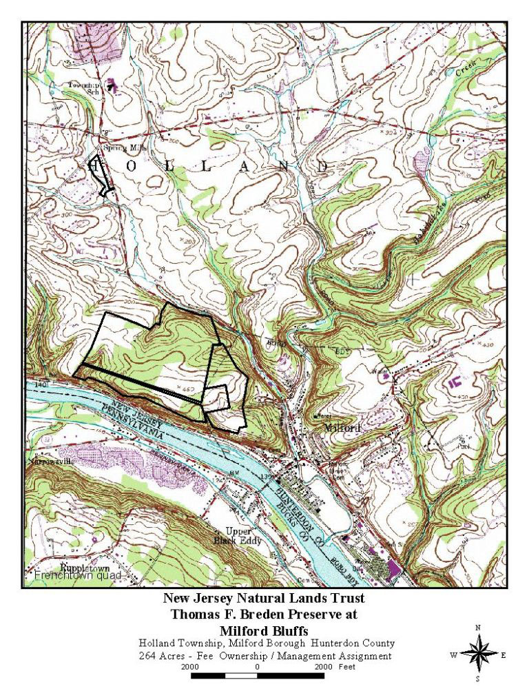
Thomas F. Breden Preserve at Milford Bluffs
Managed by NJ Natural Lands Trust
Acreage: 264
Map: http://www.nj.gov/dep/njnlt/maps/tfbreden.jpg
Parking:
This preserve is difficult to find. The sign at the entrance to a private driveway is obscure. Here are the gps coordinates of the intersection of the driveway with Rt 519: Lat 40°34'52.48"N Long 75° 6'32.53"W
Travel up the driveway, and the parking area is on the left, at a split in the driveway. The driveway ahead is private land. Here are the coordinates to the parking area: Lat 40°34'45.52"N Long 75° 6'36.95"W
Trails:
There are no formal marked trails in this preserve, and it is has been terribly maintained during previous visits.
From the parking area, follow a woods road heading east, climbing gradually. Follow the most obvious route, although it may become pretty badly grown in with multi flora rose, an Asian invasive plant. The trail route turns to the south around 0.2 mile. Many blow downs have been encountered in this area. By 0.4 mile, the trail comes out to an abandoned old farm field, now heavily overgrown by Autumn Olives, another highly invasive asian shrub. The perimeter of the field can be hiked in either direction, and totals 1.05 miles. To the left, the trail has been occasionally mowed. This is not management by NJ Natural Lands Trust, but rather a friendly neighbor to the preserve. He told us he used to mow it further, but that the Autumn Olives had become too dense. Be sure not to turn off and enter his private land. Always respect private property.
Continue along the fields to the south, where an ATV trail enters the woods on the east side, close to the cliff. Follow it east, and keep an eye off to the right. Several rock outcroppings offer amazing views of the Delaware River and the Milford-Upper Black Eddy Bridge. The cliff side, which faces south, is host to naturally growing prickly pear cactus. The ATV trail continues on to private land, so soon hikers will need to turn back. Hikers will need to return to the same path to return to their cars.
Field perimeter: 1.05 miles, unblazed.
_____________________________________________________________________________________________
TISCO Property
This small park is home to the Huskies field, and the access road can be walked, providing access to the Taylor Steelworkers Historic Greenway and the TISCO building, oldest office building in America. Also, the former railroad spur to Taylor Wharton is on the site. There was once a large deck style girder trestle that crossed Washington Avenue here. It is often mistakenly believed to be the High Bridge for which the town takes it's name, but it is not.
_____________________________________________________________________________________________
Tower Hill Reserve
Managed by Hunterdon County Parks Department
Acreage: 216
Maps:
Tower Hill Map: http://www.co.hunterdon.nj.us/depts/parks/ParkAreas/TowerHill/trailmap.pdf
Tower Hill and Jugtown Mountain map with Highlands Trail: http://www.co.hunterdon.nj.us/depts/parks/ParkAreas/TowerHill/TowerHill-JugtownConnectorTrailMap.pdf
Parking
Pull off parking on Mountainview Road: Lat: 40°40'9.56"N Long: 75° 0'11.70"W
Trails:
Highlands Trail (Teal diamond blazed): A section of Highlands Trail passes through Tower Hill Reserve. After following Mountainview Road, it turns into the park and follows the field trails before exiting into the woods. It continues to Jugtown Mountain Nature Preserve. It is the only blazed trail in Tower Hill. (For more information on the Highlands Trail: See Long Distance Trails)
Field Trails: Many field trails criss cross on both the east and west sides of Mountainview Road. To the east, there is the historic Tower Hill House, once the home of Thomas Edison's bookkeeper. Built in 1848, Hunterdon County plans to demolish this building, sadly. On the farthest east edge of the reserve, where the trail passes beneath utility lines, there is a nice view to the east.
_____________________________________________________________________________________________
Union Forge Park
Managed by: High Bridge Boro
This small park in High Bridge Boro was once home to the Union Forge. Although there are no formal trails through this park, it offers a nice walk on it's perimeter along the South Branch of the Raritan, and the Central Railroad of NJ fill and arches where the High Bridge once stood, for which the town takes it's name.
_____________________________________________________________________________________________
Voorhees State Park
Managed by NJ Parks and Forests
Acreage: 1400
Map and guide: http://www.nynjtc.org/hike/voorhees-state-park-loop
Parking:
Loop Road near Parcourse and Ranger Office: Lat: 40°41'45.25"N Long: 74°53'16.75"W
Activity fields with Hill Acres access, at ranger building: Lat: 40°41'42.07"N Long: 74°53'22.83"W
Hoppock Grove for access to all trails except Vista and Solar System: Lat: 40°41'35.93"N Long: 74°53'39.38"W
Observatory Road at Cross Park and Vista Trails: Lat: 40°40'51.14"N Long: 74°54'20.87"W
Overlook parking area, parking for Solar System and Hill Acres Trails: Lat: 40°40'55.01"N Long: 74°53'53.26"W
Buffalo Hollow Road Gold Trail Access: Lat: 40°41'57.84"N Long: 74°53'33.23"W
Trails:
Highlands Trail (Teal diamond blazed): A section of the HT passes through Voorhees; it enters on the loop road, passes the ranger station and activity fields, then turns left at Hoppock Grove parking. It continues across a bridge, turns right on a wider path, then abruptly left on the Cross Park Trail. It follows Cross Park Trail through lovely woods and past old foundations, then across the power line and down to Observatory Road. It crosses and follows Vista Trail for a bit, but then cuts away down hill to a former house site. It then comes out on Poplar Lane where it turns right. Highlands Trail may be rerouted through portions of the park. (For more information on the Highlands Trail: See Long Distance Trails)
Cross Park Trail (White blazed; sometimes sloppily): This trail is part of the Highlands Trail system. It's white blazes are marked in addition to the teal Highlands Trail ones. From Hoppock Grove, it crosses a bridge, turns right on a wide trail where Hill Acres Trail goes left. It then abruptly turns left where Brookside Trail goes straight. Cross Park Trail passes some foundations of probably old farms, probably dating from before the days of former governor Foster M. Voorhees for whom the park is named, and then crosses some washed out areas. It contineus through nice woods, then crosses a power line before descending to it's end at Observatory Road where there is more parking.
Hill Acres Trail: Named for the former estate at the site, Hill Acres Trail makes it's way from Hoppock Grove south behind the activity fields, then turns sharp to the right through swampy area. A side path leads to the right to the camp grounds where the Hill Acres Trail turns left. Most of the trail is a woods road until this point, where it becomes a foot path for the remainder of the distance across the power line and out to Observatory Road across from the Overlook parking lot. The view overlooks Round Valley Reservoir in the distance.
Solar System Trail: This short trail has interpretive signs along it's route from the overlook parking area to the Observatory. Built in 1965, here is one of the largest privately owned telescopes in NJ, a Newtonian Reflector.
Vista Trail (Pink blazed; non standard): The beginning of this trail is also the route of the Highlands Trail, with it's teal diamond blazes. From the parking area on Observatory Road near Buffalo Hollow, Vista Trail descends and crosses a small bridge, followed by a large wooden bridge over a deep wash. It then continues along the edge of the hillside. Highlands Trail cuts away, and Vista Trail continues along the edge, then heads up hill and enters young birch forest. After the birch forest, spuratic blazes sometimes make the trail difficult to follow. It follows an old woods road briefly, then heads up hill rather steeply to a seasonal overlook where Spruce Run Reservoir can be seen. The trail then passes George's Thrones, two stone chairs constructed by Voorhees State Park's former maintenance supervisor. Vista Trail then descends gradually to Observatory Road.
Brookside Trail: This trail breaks away from Cross Park Trail near Hoppock Grove. It descends on a wide path down to a shelf overlooking Willoughby Brook, making it one of the loveliest trails in Voorhees State Park. Gold Trail breaks away on the left, and Brookside Trail continues to Loop Road.
Tanglewood Trail: This trail makes it's way near the former camp site area, on a wide path connecting the Loop Road with Hoppock Grove in front of the pavilion.
Gold Trail (Wilhelm Way on old maps): This trail heads down across Willoughby Brook from the Brookside Trail, then forks in two directions. To the left, it passes very close to Willoughby Brook, then loops back through dense thickets of invasive Autumn Olives to a short distance from the Willoughby Brook Bridge on the right fork. The right fork continues through Autumn Olives in often wet areas into former farm fields. An access to the left leads to a new parking area on Buffalo Hollow Road. The Gold Trail turns to the right and crosses Willoughby Brook again on a longer foot bridge, and comes out in a field below the group picnic site. It turns right and skirts the field, enters the woods, crosses a small bridge, and terminates at the Loop Road.
Parcourse Circuit: This short excersize trail begins at the parking area just within the park from Rt 513. It passes several exercise stations, and an unnamed connector trail leads to the right shortly to connect to Hill Acres Trail. Another unnamed trail parallels Parcourse Trail, sandwiched between it and the activity fields.
Company Street: Unblazed. This short trail begins near the ranger station. It follows a former road down hill past foundations left from when the area was Camp Voorhees, a Civilian Conservation Corps camp set up in 1933. Company Street ends shortly at the loop road across from the group picnic area.
_____________________________________________________________________________________________
Union Furnace Nature Preserve
Managed by Hunterdon County Parks Department
Acreage: 97
Map: http://www.co.hunterdon.nj.us/depts/parks/ParkAreas/UnionFurnace/trailmap.pdf
Parking: Parking access is through Spruce Run Recreation Area's 24 hour lot on Van Syckles Road:
Lat: 40°40'24.99"N Long: 74°55'3.54"W
Trails:
Highlands Trail: A section of the Highlands Trail passes through this preserve. After following Van Syckles Road from Rt 31, the trail turns right into the park along Spruce Run Creek. It follows the berm of an old mill race for a bit before steeply ascending the hillside. During moist warm seasons, mushrooms grow rampant on this hillside.
After reaching the near top, turn left and descend slightly. The HT then skirts the edge of the hillside with seasonal views of Spruce Run Reservoir. It makes it's way through dense undergrowth before emerging at the cul de sac known as Serpentine Drive, which it follows down hill. (For more information on the Highlands Trail: See Long Distance Trails)
_____________________________________________________________________________________________
Wescott Nature Preserve
Managed by Hunterdon County Parks Department
Acreage: 182
Map: http://www.co.hunterdon.nj.us/depts/parks/ParkAreas/Wescott/trailmap.pdf
NJ Trails map: http://www.njtrails.org/trailmap.php?TrailID=92
Parking:
Main lot, Raven Rock Road: Lat 40°25'19.27"N Long 75° 0'15.97"W
Strimples Mill Road, Peters Trail: Lat 40°25'43.91"N Long 75° 1'9.78"W
Zega-Lockatong lot on Raven Rock Rd: Lat 40°24'58.30"N Long 75° 1'4.33"W
Trails:
Wescott Trail: 0.76 mile, orange blazed, paint and plastic hunterdon markers. This short but scenic trail forms a loop from the main parking area on Raven Rock-Rosemont Road. Beginning to the right side of the parking area, it descends through fields and enters the woods. It begins to cut to the left skirting the property boundary, and crosses a series of puncheons over a wet area, constructed by Doug Kiovsky, Adam Johnson, and M'ke Helbing in 2009. The trail then follows along the top of cliffs above the Lockatong Creek. Step carefully. The trail exits the woods and follows along the edge of a field, then re-enters the woods on the other side. It continues to near the property boundary where an unmarked side trail leads down to the creek. This was once an official trail route, but most blazes have been removed. The official trail turns sharply to the left at a fence that denotes private land. Mimi's Trail can be seen across the creek below.
The trail ascends from the creek gradually through the woods. An historic school house building is within sight to the right of the trail through the woods. The trail continues out to the fields and crosses to the parking lot to close in the loop.
Note: The Wickecheoke Creek Trail system is only 0.9 mile from this parking lot. To reach it, follow Raven Rock-Rosemont Road to the east, to the village of Rosemont, then turn right on Rt 519. A trail follows a field to the left. See Wickecheoke Creek Preserve.
Ralph Peters Trail: 1.7 miles, orange blazed, paint and hunterdon diamond markers. Beginning at Strimples Mill Road, the Peters Trail makes it's way along the right side of a field. Watch closely for a right turn where the trail cuts through a tree line and enters another field, skirting it's left edge. At the end of this field, it enters a wooded section and continues across two wet areas, one of which is bridged. It is very small. The trail continues through young forest and turns right just before entering another field. The trail turns right at the field, skirting it's right side through another opening to another field. The trail turns left here. There should be a post with a turn blaze, but they do get vandalized.
The trail continues along this next field along it's left side and soon passes an abandoned deer hunter's platform. Do not try to climb it; it is rotten and very unsturdy. The trail, now a seasonally mowed path, turns right to avoid a wet area. It then turns back to the left and passes on a diagonal through the corner of fields at a wide opening. This is an easy spot to lose the trail. There should be a low marker post in the right side of the opening. Beyond, the trail continues across open field to the right corner of a tree line ahead. It then skirts the tree line and enters the woods, just barely in from another field to the left. There is an old stone row to the right made of interesting flat stones. The trail leaves the fields altogether and continues to descend toward the Lockatong Creek, then turns right atop the embankment.
At about 0.9 mile, a red blazed side trail leaves to the right 0.07 mile to a small cascade along a tributary to the Lockatong. There might be orange plastic blazes as well. Pay closer attention to the red painted ones. In Hunterdon, they often opt to blaze trails with two markers to show beginning and end rather than the standard three. Many had gotten lost at this dead end trail prior to the addition of the triple blaze because they were looking for the trail.
The main trail continues along the level above the creek, passes through a stone wall, then descends toward the creek. The descent is gradual at first, and then becomes much steeper. Student Conservation Association did trail work in this area to re-route one spot. The trail used to go out onto the Lockatong Creek on a line of stones which was seasonally wet, but has been moved.
The trail continues through woods and turns away from the creek a bit. It is a wonder why the trail was not kept along the scenic Lockatong, but it returns to it after a short while. The trail also passes an old root cellar off to the right and building foundations, probably an old farmstead. The trail ends abruptly where Mimi's Trail begins and heads into the Zega-Lockatong Preserve with red blazes. The change in blazes is really the only thing to show the change. Blazes in the Zega section are non standard, while the Hunterdon preserve has standard as well as plastic blazes.
_____________________________________________________________________________________________
Wickecheoke Creek Preserve
Managed by NJ Conservation Foundation
Acreage:
Map north: http://www.njconservation.org/preserves/WickecheokePreserveTrailMap-north.pdf
Map south: http://www.njconservation.org/preserves/WickecheokePreserveTrailMap-south.pdf
Parking:
Prallsville Mill, Rt 29: Lat 40°24'33.50"N Long 74°59'9.01"W
Trails:
The Wickecheoke Creek Preserve contains several excellent trails between Prallsville and Locktown along the route of the creek. Two other smaller preserves, the Huey Property and Turnquist-Orbach Property closer to Flemington also have trails around the headwaters of the Wickecheoke. The sections of the creek between Prallsville and Locktown are best however. Trail sections can be connected by quiet back road walks making for an excellent hike. All trails are marked, sometimes minimally with very nice standard size diamond NJCF markers. The trails lack many turn blazes at appropriate points, and it can be somewhat grown in, but otherwise it's an excellent system.
Much of the foot path is designated Donald and Beverly Jones Memorial Foot Path
Prallsville to Locktown: Blazed with NJCF diamond blazes, good size but with few standard turn blazes. The route described is the best point to point between the two sites.
0.00 John Prall House, by the pond across from Prallsville Mill. Head south to Rt 29 where the route connects with Delaware and Raritan Canal and the old Bel Del Rail Bed (See Long Distance Trails). Turn right and follow Rt 29 north.
0.30 Reach the intersection with Rt 519 just after crossing the bridge over Wickecheoke Creek. The trail enters the woods along the creek to the right. This trail can be obscure in many places, so please use caution to be sure the blazes are seen. The trail comes close to the creek at a fast moving section of water and a beautiful pool, with a steep slope on the other side. Worman Road is just up the slope.
0.62 The trail reaches Lower Creek Road. To the left, the road leads back to Rt 519. An interesting set of steps lead up hill on private land across. To continue on the trail, walk Lower Creek Road north.
0.83 Where a field appears on the left, two possible routes are available. The most off road route is to go to the left and follow the edge of the fields, which is lovely. Similarly, the road is also a beautiful walk because it remains close to the creek. The distance difference is almost nothing. Along the road there is also an opening where there is a nice view of the rocks jutting out of the creek. These become more pronounced further up stream, when the form a sort of natural stair case.
1.20 Trail junction. The field trail, now close to Lower Creek Road again, leaves three alternatives. Straight leads out to Lower Creek Road, to the right is the edge of a field which also leads to Lower Creek Road near the cleared view of the rocks in the creek, and to the left the trail leads up hill through fields to Loop #1. It follows the edges of fields between here and Rt 519 just south of Rosemont. Note that a right turn from this trail on Rt 519, followed by a left on Raven Rock-Rosemont Road leads in only 0.9 mile to Wescott Nature Preserve.
Just ahead, where the trail reaches Lower Creek Road again, it is worth the brief side trip across and along the trail along the creek back down stream to the clearing, then return on the road or along the field to the left. To continue north, cross the road bridge over Wickecheoke Creek.
1.50 Watch closely for a trail breaking off to the left from here. It leaves Lower Creek Road and follows the stream more closely. It may be somewhat grown in, but the stream side vegetation isn't that thick.
1.85 The trail returns to Lower Creek Road. Turn left and continue on the road north.
2.00 The creek turns somewhat away from the road to the left.
2.23 Pass driveways after crossing a utility right of way. The road returns to the creek edge.
2.60 Covered Bridge Road comes in on the right. Loop #2 crosses the creek here and ascends through woods on the other side. It then follows the utility right of way to Rt 604, Rosemont Ringoes Road back to the north. Continue north on Lower Creek Road.
3.15 Reach Rt 604 at Green Sergeant's Covered Bridge, the last remaining covered bridge in NJ. There are two bridges here, the covered structure and another stone one for opposing traffic.
There are conflicting claims to date of construction; 1866 or 1872. The bridge is unique in that it's superstructure is composed of a modified Queen Truss rather than the typical Burr Truss found in the many covered bridges of eastern PA. The bridge was damaged by a storm in 1960, and was taken down. Public outcry forced the bridge to be re-assembled with it's original materials and put back in place, a rare case of successful grassroots historic preservation in Hunterdon.
The Loop #2 closes in here from Rt 604. There is a short trail along the east side of the creek, near the bridge at a picnic site. It is a dead end. Turn left through the covered bridge, then turn right on Upper Creek Road. An alternate route would be to turn right, then left on Pine Hill Road, which is a lovely unpaved back road.
3.25 Pass intersection with Sanford Road on the left.
3.38 Pass farm driveways on both sides of the road.
3.60 The trail enters the woods again to the right and begins to descend. Parking available here. There is an abandoned building to the left as the trail descends. It becomes rather steep, then crosses the creek.
3.70 Other side of the creek. A dead end trail turns right and goes to private land. Turn left here following the Wickecheoke up stream.
4.25 In this area, the trail crosses the creek again. It may not be obvious where to go, so please exercise caution and look for trail markers. On the other side, continue right heading up stream.
4.60 With thick woods on both sides, the southern end of Loop #3 is directly across the creek. It will be necessary to cross to it before the trail on the west side heads to the left, up hill and away from the creek.
4.75 The trail begins ascending to the left. It leads back to Upper Creek Road. This route can be used by turning right on Upper Creek Road, but the most off road walking involves crossing. On the other side is the #3 Loop. When reached, hikers should turn left, although right leads to the same point eventually.
5.25 After turning away from the creek the trail reaches Pine Hill Road after an ascent. This very nice dirt road can also be used to reach Green Sergeant's Covered Bridge for a return route. To continue north from the bend in Pine Hill Road, turn left.
5.40 Reach the intersection with Old Mill Road on the left, and turn onto it, descending.
5.77 Cross Wickecheoke Creek on the road bridge
5.83 Turn right on Upper Creek Road.
5.90 Turn right into the woods on another foot path. This one seems to continue along the creek somewhat, but it leaves public land. Please do not trespass.
Ahead, there are more public access points along Upper Creek Road, which soon changes names to Wickecheoke Road. Watch closely for signs with public land signage and respect all private property owners. Wickecheoke Road is a dirt road, and is excellent for hiking anyway.
7.15 Reach intersection with Kingwood-Locktown Road and turn right. Immediately cross the Wickecheoke on a bridge
7.45 Limited parking is available at Locktown Stone Church. From here it is a long road walk to connect with the next Wickecheoke preserves.
Loop #1: 1 mile, minimally blazed, not to standard with NJCF diamonds. This loop trail follows around the edges of fields and connects Lower Creek Road with Rt 519 just south of Rosemont. A 0.9 mile road walk from here leads to Wescott Nature Preserve.
Loop #2: 2 miles, blazed not totally standard with diamond NJCF markers. This route follows a trail steeply from the Wickecheoke Ceek in the Rosemont Valley and follows utility right of way, Rt 604, Lower Creek Road, and passes through the historic Green Sergeant's Covered Bridge.
Loop #3: 1.5 miles, marked with NJCF plastic diamonds, not to standard. This trail passes through lovely woods, through fields, and along part of the unpaved Pine Hill Road.
_____________________________________________________________________________________________
Zega-Lockatong Preserve
Managed by NJ Natural Lands Trust
Acreage: 70
Map: http://www.njtrails.org/trailmap.php?TrailID=92
Parking:
Raven Rock Road at Lockatong Bridge: Lat 40°24'58.30"N Long 75° 1'4.33"W
Trails:
Mimi's Trail: 0.75 mile, non standard red diamond blazed. This trail is named for Mimi Conklin Upmeyer, first administrator for Hunterdon Land Trust. It begins at a parking lot near the Raven Rock Road bridge over the Lockatong Creek. It ascends into a field and passes through a plantation of American Chestnuts with tubes around them to protect against deer browsing. Note that the preserve can be followed through the fields parallel with Raven Rock Road to shorten the 0.3 mile road walk to White Oak Trail in Delaware River Bluffs State Park across the intersection with Federal Twist Road.
The trail continues past a picnic bench as it enters the woods, then follows the slope of a hillside skirting the Lockatong flood plain. It crosses a few puncheons and then follows a wide track, probably a former roadway close to the Lockatong Creek in a lovely section. Mimi's Trail ends and Ralph Peter's trail continues after about 3/4 of a mile. At this point, there is a bench closer to the river which overlooks a lovely cascade at an Argillite outcropping.
See Wescott Nature Center for Peters Trail.

Hosting courtesy of Firebrand Communications. Website design by SGF Studios
©2012 Metrotrails unless otherwise noted • All rights reserved