Long Distance Trails – Sussex Branch Trail


NEW YORK/PHILADELPHIA METROPOLITAN AREA
OPEN SPACE RESOURCE LIBRARY
Sussex Branch Trail
Mileage:
Map: http://www.nynjtc.org/catalog/maps
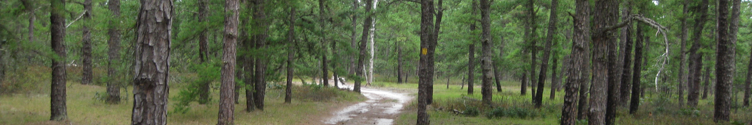
One of the premier rail trails in the Skylands is the Sussex Branch Trail. Formerly the Sussex Branch of the Delaware, Lackawanna, and Western railroad, this line is steeped in history as well as remarkable scenery. With only a few short interruptions, it is possible to trace this abandonment over twenty miles between the towns of Netcong and Branchville.The chronology of this railroad's lifespan is of particular interest. Its predecessor, the Sussex Mine Railroad, spanned only seven miles from Waterloo Village on the Morris Canal to Andover Iron Mine just northeast of the town of Andover.
Completed in 1851, this line was narrow gauged, meaning the rails were only forty inches apart. The Mine Railroad relied on mules to pull the ore carts rather than steam engines. This line is referred to as a "predecessor" because the Sussex Railroad, built in 1854 and extended to Newton, utilized only about two miles of the "mine" railroad's right of way. Both lines were the brainchild of Abrahm S. Hewitt, a mining pioneer at Long Pond near Ringwood as well as co-founder of the Cooper-Hewitt furnaces in Phillipsburg. Most significantly, this was Sussex County's first railroad.The Sussex Branch’s hard cinder path cuts through rock and woods on the southern end, skirts the shores of Cranberry Lake and widens into open fields north of Newton.Walk from the trail's main southern access point on Waterloo Road in Byram Township, across from International Drive at the Trade Center through a beautiful wooded area, skirting Jefferson Lake to the east. Some deviations the mine railroad had from the newer line are now part of Allamuchy Mountain State Park and can make interesting return routes for out-and-back hikes. In fact the Highlands Trail, marked with teal diamonds and linking New York State southwest across Sussex and Morris Counties to the Delaware River in Warren and Hunterdon Counties utilizes both the mine railroad bed and the main line.The trail continues to the beautiful former resort community, Cranberry Lake, as well as Kittatinny Valley State Park where a variety of circuit hikes are possible. It passes through the towns of Andover and Newton, traverses the swamps of the awe-inspiring Newton Meadows, meets the Paulinskill Valley Trail at Warbasse and heads for the quaint village of Lafayette. At its north end, the rail-bed traverses a great deal of farmland and offers beautiful scenery of the Paulinskill River and it's tributaries.Later, in 1869 the Sussex Railroad was extended to Branchville, the trail's northern terminus where you'll find an antique store, a weekend flea market, as well as plenty of eateries. While plans were made to extend the railroad through Culver's Gap, they never came to fruition.
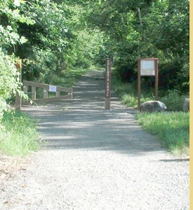
The Sussex Branch Trail as a State Park owned trail begins at the parking lot on Waterloo Road, but the first section of "trail" is actually along Continental Drive, just a bit north of International Drive in International Trade Center near the Holiday Inn. The southern section was actually not part of the main Sussex Branch, but rather the "cutoff" to Stanhope built in 1901 that rendered the older line obsolete. Though it's hard to reach, the section of the Sussex Branch from Morris Canal's Inclined Plane #4 West to the Musconetcong River is walkable, and passes by the ruins of the industrial ice company that once operated at Waterloo Lake.
Trail (Blazing None, except side trails and occasional signs)
.00 Holiday Inn parking lot. Cross International Drive and follow Continental Drive northwest.
0.20 Paved path turns away from Continental Drive. Continental Drive is built on the former rail line.
0.40 The trail crosses a small creek. Visible to the left is the fact that the original railroad culvert had been used for the road overpass.
0.60 An old road turns off to the right. It leads to an abandoned bridge over the Musconetcong River. The bridge is in poor shape and has been abandoned many years. The road joined Waterloo Road.
1.00 Reach a bridge over the Musconetcong River shortly after the paved path turns into the road and ends. A sometimes obscure fisherman's trail leads down to the left of the road. Following this will lead to the original Sussex Branch, where it once crossed the Musconetcong River. Now only abutments and one pier remain. This path can become quite overgrown and is sometimes wet. In addition, the path offers views of the Contenental Drive bridge over the Musconetcong. While the bridge is new, it was constructed on the abutments of the old railroad bridge! An impressive re-use of sturdy masonry.
1.15 Reach Waterloo Road and cross into the southern parking lot for the Sussex Branch Trail in Allamuchy Mountain State Park. The trail is original cinder with occasional crushed stone here.
1.40 After passing around the locked gate, reach the former junction site with the main Sussex Branch and the 1901 Cutoff (which the trail route follows). The original right of way is now part of the Waterloo-517 Trail. This right of way can be followed south across Waterloo Road and to the former Musconetcong trestle site, about 0.1 mile south of here. It is also the route of the earlier Sussex Mine Railroad, which breaks from the Sussex Branch to Waterloo Village before the trestle site. A bit of the fill for this line is visible along Waterloo Road, but it is mostly obliterated.
1.50 Reach Jefferson Lake on the right. Soon, the original Sussex Mine Railroad right of way, a narrow gauge mule railroad and predecessor to the Sussex Railroad, breaks away to the left. The main trail continues ahead on a fill over a finger of Jefferson Lake while the older right of way hugs the side of it on a shelf. It rejoins the main trail ahead with minimal extra distance. To the right, a former ice house siding breaks away from the main trail. It leads to a private camp.
2.00 Old mine railroad right of way rejoins. The Highlands Trail briefly joins the Sussex Branch Trail, having descended off of Allamuchy Mountain to the west to join the Sussex Mine Railroad right of way. It runs concurrently with the Sussex Branch Trail shortly to a small waterfall on the right. Here, it crosses the stream to continue north on it's journey to Storm King Mountain, NY and beyond. To the south, it leads to Rieglesville PA. The Liberty-Water Gap Trail also joins, and follows the Sussex Branch Trail north to Warbasse Junction.
3.10 Reach a parking area accessed from South Shore Road. Continue around the gate ahead on the access lane built on the rail bed.
3.20 Cross South Shore Road diagonally heading toward Cranberry Lake.
3.30 Reach another parking area along Cranberry Lake. Turn left through an opening in wooden fence line and follow the crushed stone path along the eastern shore of Cranberry Lake, once a thriving resort village.
3.50 This section bears little resemblance to the railroad it once was. Pass behind a building along the shore as well as the public beach open to residents of Cranberry Lake. Soon, pass by a foot bridge over a narrow section of Cranberry Lake, also open to residents only.
3.70 Reach the southern end of a commuter lot along Rt 206. It has been built over the rail bed. There is a convenience store across Rt 206 from here.
3.80 Leave the commuter parking lot and reach North Shore Road. The rail bed continues to closely parallel Rt 206. Waving Willy Trail soon departs to the left, leading into Allamuchy Mountain State Park. Ahead, Rt 206 is much higher than the rail bed, but it's retaining wall encroaches on the trail, making for sometimes narrow walkway. There is some ballast rock. Soon pass a quarried area on the left.
4.27 Cross the lower end of Whitehall Hill Road. The trail is extremely wet ahead, as a creek flows in the rail bed. Hikers may wish to parallel on Whitehall Hill Road which runs close by. Near this road crossing, the original Sussex Mine Railroad deviates from the later route. It continued out to along Panther Lake. It is now on private land.
4.70 The trail comes to the same level as Whitehall Hill Road. The road turns away to the left, and also continues straight to parallel the rail bed. The rail bed continues ahead on a fill. It is badly washed out at this point. Use caution and skirt the right side of the washout, and the less disturbed trail resumes.
4.90 Cross a local landmark, a culvert known as "The Hole In The Wall", an old masonry culvert through which Whitehall Hill Road passes. This is the village of Whitehall.
5.20 Farm crossing. Old rail beds often have old farm underpasses which allowed for safe passage of equipment or animals above or below the tracks.
5.50 The rail bed passes beneath the Lackawanna Cutoff. The cut and fill project for this railroad was the largest of it's kind in human history. The people of Andover were irate over the construction of this fill, which obscured the view. Abandoned in 1979, the tracks were torn up in 1982. There are plans to reactivate the line for commuter service.
5.70 Cross High Street in Andover after paralleling Rt 206 closely again. Continue ahead and cross Maple Street at 5.77 miles.
5.85 Cross Brighton Ave. To the left before the crossing is an old switch box. Continue along the edge of a parking lot ahead, parallel with Railroad Ave.
5.95 Cross Smith Street and reach another parking area for the trail. Enter the woods with houses below on the right, and fields above to the left. The earlier mule drawn Sussex Mine Railroad remains on the other side of Rt 206, and sections of it are visible from the highway on private land. Ahead, the later spur track to the Andover Mines broke away from the Sussex Railroad. The junction site is rather obscure today.
6.68 Cross the abandoned right of way of the Lehigh and Hudson River Railroad (1886-1986). To the left, the right of way is in public ownership for a good distance, but it is not very clear. To the right, it goes through a parking lot to Rt 206. On the other side of 206 it is on public land again, but is not very clear there either.
6.85 Cross Rt 206 and reach a large parking area for Sussex Branch Trail, and enter Kittatinny Valley State Park.
7.20 The trail crosses over the eastern section of Whites Pond on a causeway.
7.40 After skirting the wetland on the west, the trail enters woods and leaves the wetland.
8.00 The trail crosses, and then parallels Goodale Road. A trail on an old woods road comes in to Goodale Road to the right .16 miles ahead.
8.25 An access road crosses the trail, from a parking lot in Kittatinny Valley State Park to the right. The access road connects with other trails, and leads to a cell tower to the west. Ahead, the trail passes through nice rock cuts and through beautiful rocky outcroppings.
9.10 Reach a utility line crossing.
9.70 Cross Yates Avenue and parallel Stickles Pond Road.
10.18 Cross Newton-Sparta Road at the site of a former bridge. Use caution. The road is very busy and wide. Climb the fill on the other side and parallel Drakes Pond to the right.
10.30 Though it is obscure, this is where the earlier and later Sussex Branch diverge. Originally, the Sussex Railroad bypassed the town of Newton altogether turning right here. The "Newton Cutoff" was constructed later, and actually added mileage to the line, and it offered service to the town directly.
10.38 Reach Warbasse Junction Road. There is a break in the trail here. Officially, those following the trail through should turn right here. "Newton Cutoff" mileage is presented at the end of this guide.
10.63 The road joins the former railroad right of way.
10.95 Cross utility right of way.
11.30 Cross another utility right of way on the road.
11.47 The trail turns off to the left and enters the woods. It soon joins the "Newton Cutoff" Sussex Branch right of way.
11.70 Warbasse Road turns away from the rail bed. The original Sussex Branch and later "Newton Cutoff" are now back together. Continue north through woods, skirting wetlands to the left.
13.60 Reach site of former Franklin Junction. Here, the Franklin Branch of the Delaware, Lackawanna, and Western Railroad broke off to the right near an old building. It is on private land at this point, but is recognizable. It continued to Franklin where it made connections with mines, industries, and other rail lines.
13.85 Cross Warbasse Junction Road.
13.92 Warbasse Junction. Once a significant railroad junction, it is now the junction of the Sussex Branch Trail with the Paulins Kill Valley Trail. Paulins Kill Valley Trail leads right to Sparta Junction, and left to Columbia. Continue ahead. Liberty-Water Gap Trail leaves the Sussex Branch here, following PKV Trail to the left.
14.00 Cross a bridge over a stream, a tributary to the Paulins Kill River.
14.65 Cross Rt 94. Use caution.
15.05 Reach Morris Farm Road in the village of Lafayette. Cross the road and continue on the rail bed. There are stores where food may be purchased a short distance to the right.
15.25 Pass a municipal park on the right, with a nice pond, fountain, and swimming beach (for residents) on the right, followed by a stagnant pond on the left of the trail. There are some washed out sections.
15.70 Cross Valley View Road after a nice, pleasant section with rocky outcroppings. Despite pleasantness, there are a few sections with ballast rock.
15.80 Fields are on both sides of the trail at this point.
16.08 Cross Decker Road.
16.35 Cross the Paulins Kill River, here just a small stream, on a small bridge. Continue through farm lands.
17.00 Cross the Paulins Kill River again on a small bridge
17.10 Cross Rt 206 with extreme caution.
17.30 Cross the Paulins Kill River yet again on a small bridge and parallel it closely on the left.
17.90 Cross the Paulins Kill yet again just after crossing a small farm lane.
18.10 Just after crossing August Hill Road, reach the former Lehigh and New England Railroad (1886-1962). It was once a substantial line between eastern Pennsylvania an Poughkeepsie NY. The decline in the coal industry is credited with the demise of the line. It is currently under development as a trail. After crossing the LNE right of way, cross the Paulins Kill River once more on a bridge.
18.40 Farm crossing
19.25 After paralleling Dry Creek where there are some significant washouts in the trail (use caution), reach the Rt 206 underpass. Continue.
19.53 Reach Mill Street in Branchville. The trail officially ends in this area, although it tends to be very obscure in regards to signage. A left hand turn on Mill Street offers a better view of old bridge abutments over the creek. The rail bed continues through a strip of woods, and over a creek on an undecked bridge with metal ties, then emerges at a business with an old passenger car on a restored piece of track. The car bears the name "Lackawanna".
19.70 County Rt 630. For those wishing to reach this site, a right turn from Mill Street onto Milk Street will lead to Rt 630 without trying to bushwhack through on the rail bed or over an undecked bridge.
It is apparent that the tracks continued a block or two north of here at one time, but all signs of this appear to have vanished. All that remains is a street that bears the name "Railroad Avenue".
The “Metrotrails Special” Sussex to Acopolis Connector:
Although the trail ends in Branchville, it is not too far a distance to Stokes State Forest and Acropolis Trail:
0.00 Rt 630 at the passenger car, Branchville, head west. Follow Rt 630 through the pleasant town of Branchville.
0.78 Rt Rt 206 and turn right.
1.05 Intersection with Cook Road and Rt 630
2.15 Pass Lakeview Point Ave on the right.
3.00 Pass Rt 521 intersection on left.
3.20 Lower terminus of Acropolis Trail. It leads steeply up the Kittatinny Ridge on an old woods road to the Appalachian Trail (See Stokes State Forest)
Newton Cutoff
Some of this section of railroad right of way may not be in public ownership.Please respect private land owners.
0.00 From Warbasse Junction Road, turn left where the official route follows the road to the right, then turn right on Rt 206. The rail bed goes into people's back yards in the section ahead.
0.18 The fill on which the railroad once was is plowed away at a rental center. Continue along Rt 206 to the right.
0.25 Pass Quick Check on the left.
0.37 Just before the intersection with Diller Ave, turn right into a parking lot and continue to the left on the level grade, parallel with Rt 206. Cross Diller Ave and continue through the parking lot.
0.75 After following the railroad right of way between buildings, and through parking lots, reach Spring Street. Cross.
0.93 Cross Trinity Street. The rail bed ahead becomes badly washed out.
1.10 Begin to parallel the Newton Meadows. Few historic pictures exist of this area. It was considered a taboo place to go, even back then.
1.30 The rail bed reaches the western end of an expansive and beautiful meadow.
1.50 Reach a former bridge site. This was a beam bridge, meaning it was constructed of only wood. This was reportedly the only remaining beam bridge on any Lackawanna line at the time of it's abandonment. Even in the coldest of Summer days, the water runs freezing cold here. This is because it bubbles up out of the ground just to the right of the trail. To the left, another stream that joins obviously feels warmer to the touch.
There is no official bridge over the site, and so it is necessary to get wet feet or construct a bridge out of debris. Many times I have visited and found makeshift bridges had been constructed.
1.65 Reach the end of the wetland valley.
1.95 The "Newton Cutoff" rejoins the trail route.

Hosting courtesy of Firebrand Communications. Website design by SGF Studios
©2012 Metrotrails unless otherwise noted • All rights reserved